
WELCOMES YOU AND PRESENTS
All About

Non Nobis Sed Patriae


I am a Canadian, free to speak without fear, free to worship in my way, free to stand for what I think is right, free to oppose that which I believe wrong, and free to choose those who shall govern my country. This heritage of freedom I pledge to uphold for myself and mankind.
John Diefenbaker (From the Canadian Bill of Rights, July 1, 1960)
CLICK LINK IN LEFT FRAME TO VIEW

KNIGHT AND VAUGHAN FAMILY TREES
Early Exploration
 The earliest records of life in North America begin in a warmer age, when people moved across the Bering land bridge or travelled by water and ice and made a home in what is now the Canadian Arctic. People have been living in the Yukon region for almost 30,000 years. The aboriginal people who crossed the land bridge were the first inhabitants of North America. Many settled in various areas, including the northern tundra, while some moved south to the warmer climate and good hunting found there.
 Eric the Red brought the Vikings to Greenland, where they lived for about 500 years, then died out. They were farmers who built their huts of dirt and timber, with sod roofs. They raised sheep, goats and cattle imported from Norway. Life span of these early Viking settlers was about 30 to 35 years. It is believed they died of disease or starved to death when crops failed due to severe weather (possibly a mini ice age) about the year 1500. Remains of their settlements remain today.
Around the year 1000 Leif Ericsson and other Vikings explorers sailed into into Labrador waters and at L'Anse aux Meadows, Newfoundland they made landfall to gather provisions and replenish their supply of drinking water for the long return voyage to Europe. Historians believe that Leif landed somewhere on the northernmost tip of Newfoundland on the Strait of Belle Isle. The theory was confirmed in 1963, after a Norwegian expedition uncovered the remains of a Viking settlement near the fishing village. Some hut ruins and small stone markers have been credited to them. It is believed that they stayed in the area for a period of time to rest and hunt.
 In 1497 John Cabot claimed Cape Breton Island for Henry VII of England during his first voyage to the new world. 1498 saw John Cabot make his second voyage to North America and it is believed he went ashore in Newfoundland and the mainland.
In 1577 Martin Frobisher of England make the first of three futile attempts to find the northwest passage to Asia, sailing as far as Hudson Strait.
Sir Humphrey Gilbert (c1537-1583) arrived off Newfoundland in 1583 with his ships Delight, Golden Hind, Swallow and Squirrel. He entered St. John's Harbour two days later to claim Newfoundland for Queen Elizabeth I of England. Gilbert set up the first English colony in North America on 5 August 1583
The first permanent English settlement in the new land that was to later become Canada, was at Cuper's Cove in Conception Bay, Newfoundland. It was founded in 1609-1610 by John Guy and a group of 39 settlers who came there because of the vast quantities of fish found there. They fell upon hard times within a few years and many of them died. A very harsh climate forced the few survivors to abandon the settlement and return to England in 1613.
Origin of the name "Canada"
 In 1535, the aboriginal people told French explorer Jacques Cartier about the route to "kanata". They were referring to the village of Stadacona - "kanata" was simply the Huron-Iroquois word for "village" or "settlement". Cartier used "Canada" to refer not only to Stadacona (site of present-day Quebec City), but also to the entire area. Maps as early as 1547 designated everything north of the St. Lawrence River as "Canada".
Jacques Cartier also called the St. Lawrence River the "rivičre de Canada", a name used until the early 1600s. When Samuel de Champlain and other Europeans began to visit (what is now New Brunswick) in the early 1600s, they were met by Maliseets and Micmacs. Some early French farmers settled at the head of the Bay of Fundy and up the St. John River Valley as far as present-day Fredericton, and called the land Acadia. In 1608 Champlain established Quebec City on the banks of the St. Lawrence river. By 1616, although the entire region was now known as "New France", the area along the St. Lawrence and the Gulf of St. Lawrence was referred to as Canada by the settlers.
NOTE: Need more info on the Early Explorers of Canada? Click here to go to our EXPLORERS page.
"We are the land" and "the Earth is our mother"
(2 old First Nations sayings)

(For Detailed Maps of Canada and the Provinces and Territories - Click here)
THE CAPITAL CITIES OF THE PROVINCES AND TERRITORIES
The following are the capital cities of the 10 Provinces (from West to East) and the 3 Territories:-
British Columbia (Victoria); Alberta (Edmonton); Saskatchewan (Regina); Manitoba (Winnipeg); Ontario (Toronto); Québec (Québec City); New Brunswick (Fredericton); Nova Scotia (Halifax); Prince Edward Island (Charlottetown); Newfoundland and Labrador (St. John's); Yukon Territory (Whitehorse); Northwest Territory (Yellowknife); and Nunavut Territory (Iqaluit).
PROVINCES AND TERRITORIES QUICK FACT SHEETS

to load the small Canada Map which will link you to individual Province and Territory Quick Facts Sheets.
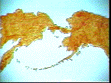
Canada is a BIG country!
Area: 9,970,610 sq. km. (3,849,652 sq. mi.)The estimated population of Canada as of 2010 is 34,000,000+.
Canada is the second-largest country in the world, by surface area. Russia is first with 17,070,000 sq. km., then Canada, followed by China with 9,597,000 sq. km. and the U.S.A. with 9,363,000 sq. km.
Canada comprises seven percent (7%) of the earth's total surface area.
It reaches more than 4,600 km. from Cape Columbia on Ellesmere Island (Canada's northern extremity) to Middle Island, Ontario (the southern-most point).
From west to east, Canada covers 5,047 km. from Victoria, B.C. to St.John's, Nfld.
The Canadian Pacific Railway and the Canadian National Railway operate 86,880 km. of track from the Maritimes to the Fraser Delta in B.C. and from the U.S border to the far North.
The Canada /U.S.A Border
The boundary between the newly formed United States and British North America was established by the Treaty of Paris in 1783. From 1818 to 1925, the line was further
established. By the 1870s, it became clear that the border needed some maintenance, not to mention some fine-tuning as to who owned what. A major resurveying of the boundary took place between 1908 and 1924.
The unguarded Canada / U.S.A. has always been calculated using metric measurements - even by the United States, which does not use metric.
The length of the boundary between Canada and the USA is 8,893 kilometres (5,526 miles), including the border between British Columbia, Yukon and Alaska. A total of 5,061 kilometres (3,145 miles) are along land and 3,832 kilometres (2,381 miles) are along water.
There are over 8000 monuments and reference points along the Canada/USA border.
FLAGS OF CANADA, PROVINCES AND TERRITORIES
The Canadian Maple Leaf flag is our proud National symbol.
Just as Canada has a National Flag, each Canadian Province and Territory has its own flag. To learn more about Canada's flags throughout history and view all the many and varied Canadian flags, click the 'Canada's Flags' button in the left frame.
Official Lyrics of O Canada (in English and French)
Previously, Canadians sang God Save the Queen/King as their anthem.
"O Canada" was proclaimed Canada's national anthem on July 1, 1980, 100 years after it was first sung on June 24, 1880. The music was composed by Calixa Lavallée, a well-known composer. French lyrics to accompany the music were written by Sir Adolphe-Basile Routhier. Many English versions have appeared over the years. The anthem on which the official English lyrics are based was written in 1908 by Mr. Justice Robert Stanley Weir.
The official English version includes changes recommended in 1968 by a Special Joint Committee of the Senate and House of Commons. The French lyrics remained unaltered.
The criticism of Weir's original version was that the words asked Canadians to "stand on guard" too many times without telling them exactly for what reason. As a result, two of the five "stand on guard's" and one "O Canada" were removed and replaced by "From far and wide" and "God keep our land". With these alterations, we now have a new national anthem.
On February 7, 2018, the English lyrics of O Canada were changed to be gender neutral, replacing "in all thy sons command" with "in all of us command".
| O Canada! Our home and native land! True patriot love in all of us command. With glowing hearts we see thee rise, The True North strong and free! From far and wide, O Canada, We stand on guard for thee. God keep our land glorious and free! O Canada, we stand on guard for thee. O Canada, we stand on guard for thee.
| Ô Canada! Terre de nos aďeux, Ton front est ceint de fleurons glorieux! Car ton bras sait porter l'épée, Il sait porter la croix! Ton histoire est une épopée Des plus brillants exploits. Et ta valeur, de foi trempée, Protégera nos foyers et nos droits, Protégera nos foyers et nos droits. |
THE GOVERNOR GENERAL OF CANADA and
THE PRIME MINISTER OF CANADA
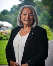
Her Excellency | 
The Right Honourable |
and exercises the duties of the Head of State as the representative of His Majesty The King..
Previous Governors General and Prime Ministers
To go to the OUR LEADERS page click the link in the left frame.
NATIONAL EMBLEMS
 The Maple Leaf
A National emblem of Canada is the maple leaf and according to many historians, it began to serve as a Canadian symbol as early as 1700. In 1834, the first St. Jean Baptiste Society in North America made the maple leaf its emblem. In 1848, the Toronto literary annual "THE MAPLE LEAF" referred to it as the chosen emblem of Canada.
In 1860, the maple leaf was formally adopted as a national emblem and was incorporated into the badge of the 100th Regiment (Royal Canadians). It was used extensively in decorations for the visits to Canada of the Prince of Wales. In 1868 it appeared on the coats of arms granted to Quebec and Ontario. Since 1921, the Royal Arms of Canada have included three maple leaves as a distinctive Canadian Emblem.
The Maple leaf today appears on the Canadian penny. However, between 1876 and 1901, it appeared on all Canadian coins. The modern one-cent piece has two maple leafs on a common twig, a design that has gone almost unchanged since 1937.
During the First World War, the maple leaf was included in the badge of the Canadian Expeditionary Force.
With the proclamation of Canada's new flag in 1965, the maple leaf has become the most prominent Canadian symbol.
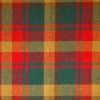 Canada's National Tartan
The Maple Leaf Tartan became Canada's official tartan in March 2011. The Maple Leaf Tartan was created by designer David Weiser in 1964 to celebrate the 100th anniversary of Confederation in 1967.
Other Canadian Symbols
The Beaver, West Coast totem poles, the RCMP Musical Ride, the birch-bark canoe, the Canada Goose, and the Schooner Bluenose are other very well-known Canadian symbols.
Visit our page devoted to the Beaver. Click Here
To go to Canada - Page 2
So we know you have visited the KCIC Web site, please
leave a comment in our GUESTBOOK
Use the Guestbook link to the left
This page is part of Knight's Canadian Info Collection
Please visit our other pages
Site © by K.C.I.C. - A. Knight (Webmaster)